Topographic Maps
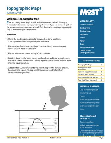
Topographic MapsBy: Nancy VolkMaking a Topographic MapWhat is a topographic map? what is an isoline or contour line? What typeVOCABULARYof characteristics does a topographic map show us? If you are wondering aboutthe answers to these questions, you will find them when making a topographicmap of a landform you have created.Contour intervalDirections:Elevation1. Using the modeling dough or clay provided, design a landform.Check your landform design with your instructor.2. Place the landform inside the plastic container. Using a measuring cup,add 1/2 cup of water to the basin.3. Place a transparency sheet on top of the container.4. Looking down on the basin, use an overhead pen and trace around wherethe water meets the landform. This will represent an isoline or contour, a lineshowing equal elevation.5. Add another 1/2 cup of water to the system. Repeat the drawing process.Continue to to repeat this step until the water covers the landformor the container gets filled.Contour lineContour mapIsolineReliefScaleTopographic mapUnited StatesGeological SurveyInside This PacketTopographic Maps1Topographic MapsWorksheetIsotherm Maps Worksheet2Isotherm Map Samples45Information for the Teacher7New York State Standards8MATERIALS NEEDEDClay or modeling doughMeasuring cupPitcherPlastic shoe box containerPlastic transparency sheetOverhead projection penWater2C1.5C1C1/2 CEarth Science - Post Module 1Middle SchoolStudents shouldbe able to:Design a landformMake a topographic mapof the landformUnderstand the basic conceptsof reading a topographic mapPage 1
Topographic Maps WorksheetName:Date:Follow Up QuestionsCompare your map to the landform and think about the following:1. Where is the steepest section of land? How does this relate to the contour lines?2. Where is the most gradual change in the landform? How does this relate to the isolines?3. What other features do you notice on the landform and how does this relate to the contour map?4. How does slope compare to the steepness of the landform? What is slope?5. Why do you think we use contour maps? What type of information does a contour map provide for us?6. Do the isolines or contour lines ever touch or cross? Why?Earth Science - Post Module 1Middle SchoolPage 2
Topographic Maps WorksheetUse the topographic map to answer questions 7 - 10.NORTH.B.E.A.FWEST.D.CEASTSOUTH7. If the first layer of your model is sea level, what elevation is each of the following points?(Contour Interval 10 ft.)ABCDEF8. Which is the steepest slope on the hill? (north, south, east, west?) How do you know?9. What is the difference in elevation between the second and fourth layers of the map?10. If you were to build a house on this hill, where is the flattest part of the landform?Draw a house in this area on the topographic map.Earth Science - Post Module 1Middle SchoolPage 3
Isotherm Maps WorksheetMaking an Isotherm MapYou have now spent some time mapping isotherms in your classroom. Use the knowledge you learned to answer thefollowing questions.1. Using the map of the classroom isotherms, explain any interesting patterns.(Note: heat sources, sinks, doors, windows, etc)2. What is the interval of the map?3. Why don’t isotherms cross or touch?4. What changes as the height of the classroom isotherm map changes?5. Other interesting observations:Earth Science - Post Module 1Middle SchoolPage 4
21.5o22o22.5o20o21o22oDoorEarth Science - Post Module 1Middle School21.5o23o22o23oHeater20.5o21oDrawing Isotherms : Sample #1with temperatures onlyoC22o21o19.5oWindowsPage 5
20 oEarth Science - Post Module 121 5o20.5o22oX21oXX22o21oX19.5ointerval 1oC2023 oDrawing Isotherms : Sample #1with temperatures and isolinesoCWindowso21o22o23oMiddle SchoolPage 622 o
Information for the TeacherModeling Dough RecipeIngredients:1 cup flour1/2 cup salt1 cup water2 tablespoons oil2 tablespoons cream of tartarMix flour, cream of tartar, salt and oil, then slowly add water. Cook over medium heat, stirring until the dough stiffens.Turn out onto wax paper and let cool. Knead the modeling dough with your hands until proper consistency.Use as is, or divide into balls and add a few drops of food coloring.Note: Plasticine does work best. If using the modeling dough, allow it to dry completely before using.Extension idea 1: Climate ChangeFill up a clear cup with water and add an ice cube. Now fill the cup of water up as much as possible withoutoverflowing the cup. What will happen to the water level as the ice cube melts? Write down your prediction.Watch and see what happens. Describe what happens. What happened to other students examples?Extension idea 2: Climate ChangeUse one of the landforms that might represent the Liberty Island in New York Harbor, where the Statue of Libertyis located. Create a small model of the Statue of Liberty and place this on the landform. Fill up an ice cube tray withsnow and place the snow on the highland area to melt. Notice what happens on the coastline with the snow melting.Start again and fill up the ice cube tray with water, add the water to the system and decide what will happen with thewater level. Make predictions about the water level before testing the model.Helpful WebsitesTake a look at real life data presented by NASA/Goddard including temperature change over cycles of seasonsand time. The site also includes other informational science data and photos of Earth.http://earthobservatory.nasa.gov/Easy to follow instructions for creating a contour Topo%20Maps.pdfInstructions for building a topographic .htmlExplore the highest elevation point in each of the 50 states using maps or by satellite images. Just click on a point anduse the zoom and pan tools in the upper left corner of the map window. Switch between maps and satellite imagesusing the buttons in the upper right. The map above shows the highest mountain or highest elevation point for eachof the 50 arth Science - Post Module 1Middle SchoolPage 7
Information for the TeacherIsotherm Map DirectionsHand out the sample fictitious classroom map with data. Ask the students to draw Isotherms using the data withan interval of 1 degree Celsius. Remind them that isotherms should never touch or cross, they represent a lineof a constant temperature. To check their work they should find higher values on one side of their lines and lowervalues on the other side of the line. Discuss the students findings and show them the actual isotherm map. Answerany questions the students may have and proceed to the next activity.1. Develop a map of the room with doors, windows, where the desk or tables are located and other details.2. Divide the classroom into 15 evenly spaced zones. Divide the class into teams of two.3. Place thermometers at the 15 locations on the floor.4. Wait 5 minutes and then record the temperatures at the 15 locations. Place the data accurately on the classroomfloor map.5. Raise the thermometers to the desk level height. Label another classroom map, “ desk top level”.Let the thermometers sit for 2 minutes. Record the temperatures at this level and transfer to the classroom map.6. Place the thermometer on a meter stick and raise them into the air for about 2 minutes. Quickly readthe thermometers temperature and record the results. Place the data on a new classroom map and labelthis map ceiling area.7. Make copies of the three maps for each team. Complete one map together using the following directions.8. Find the low point and the high temperature reading. Label the L for low and the high temperature H.9. Subtract the value of the low from the high reading to determine an easy interval.10. Work from the low temperature reading to the high temperature reading. Choose the most even lowest valuepossible and begin drawing an isotherm so that any exact temperatures will be on the line. Lower temperaturevalues will be outside of the line and higher values will be inside the line. The isotherm will curve but not havesharp points. (If this step seems confusing try the sample data sheet #1 first and check your responses).New York State StandardsMath, Science, Technology - Intermediate LevelStandard 1: Mathematical Analysis: Key Idea 1: m1.1; Key Idea 2: m2.1; Key Idea 3: m3.1Standard 1: Scientific Inquiry: Key Idea 1: s1.2, s1.3, s1.4; Key Idea 2: s2.1a, s2.1b, s2.1d; Key Idea 3: s3.1, s3.1b, s3.2eStandard 4: Physical setting: Key Idea 3: 3.1d, 3.1hStandard 6: Models: Key Idea 2: 2.2; Key Idea 5: 5.2Standard 7: Key Idea1: 1.2; Key Idea 2: working effectively, gathering and processing information, presenting resultsGeneral Skills: Metric ruler, beaker, thermometers 1,2,3,4,8 and 9Physical Setting Skills: 7Earth Science - Post Module 1Middle SchoolPage 8
Complete one map together using the following directions. 8. Find the low point and the high temperature reading. Label the L for low and the high temperature H. 9. Subtract the value of the low from the high reading to determine an easy interval. 10. Work from the low temperature reading to the high temperature reading. Choose the most even .
The authors distinguish topographic image maps and thematic image maps. 3. TOPOGRAPHIC IMAGE MAPS . The term “topographic image map” is defined analogically as with the term topographic map. Topographic maps with their topographic and hypsometric content are one of the most import
What is a Topographic Map? Mapping is a crucial part of earth science. Topographic maps represent the locations of major geological features. Topographic maps use a special type of line, called a contour line, to show different elevations on a map. Contour lines are drawn on a topographic
topographic maps to determine where roads, tunnels, and bridges should go. Land use planners and architects use topographic maps when planning development projects, such as housing projects, shopping malls, and roads. Bathymetric Maps Oceanographers use a type of topographic map that s
Topographic and geologic maps Lab experiment Reading Topographic Maps Purpose: to learn the most important parts of a topographic map, how to read the map, and how to interpret and calculate data using the map. Note: Maps used will also be available in digital format online. A. Identify
Topographic Maps The most extensive topographic maps of the United States have been compiled by the U.S. Geological Survey (USGS). The USGS has adopted a uniform set of symbols for various kinds of features, which facilitates the reading of topographic maps. Some of these symbols are il
2.1) for all surveys so that profiles obtained from all survey types (topographic, bathymetric and LiDAR) can be compared. The spreadsheet also details which profiles are to be surveyed for each survey type e.g. topographic baseline survey, topographic interim profile survey, topographic post-storm profile survey, topographic repeat baseline .
Topographical Maps Slopes on Topographical Maps Landforms on Topographical Maps Landforms on Topographical Maps What are contour lines? Contour lines are lines drawn on topographic maps joining places of equal height above sea level. On topographical maps contour lines are the brown l
Segment of a 1:250 000 scale topographic map (actual size) This is a northing This is the longitude This is the latitude This is an easting Map Reading Guide How to use Topographic Maps Preface This booklet will help you use topographic maps. It explains the types of information on topographic maps, how to interpret that information and how to .


