LAND SURVEY FROM UNMANED AERIAL VEICHLE
International Archives of the Photogrammetry, Remote Sensing and Spatial Information Sciences, Volume XXXIX-B1, 2012XXII ISPRS Congress, 25 August – 01 September 2012, Melbourne, AustraliaLAND SURVEY FROM UNMANED AERIAL VEICHLEVid Peterman, Marko MesaričUniversity of Ljubljana, Faculty of civil and geodetic engineering, Ljubljana, Sloveniavid.peterman@gmail.comKEY WORDS: Low altitude, Three-Dimensional, Non-metric camera, UAVs, Point CloudABSTRACT:In this paper we present, how we use a quadrocopter unmanned aerial vehicle with a camera attached to it, to do low altitudephotogrammetric land survey. We use the quadrocopter to take highly overlapping photos of the area of interest. A “structure frommotion” algorithm is implemented to get parameters of camera orientations and to generate a sparse point cloud representation ofobjects in photos. Than a patch based multi view stereo algorithm is applied to generate a dense point cloud. Ground control pointsare used to georeference the data. Further processing is applied to generate digital orthophoto maps, digital surface models, digitalterrain models and assess volumes of various types of material. Practical examples of land survey from a UAV are presented in thepaper. We explain how we used our system to monitor the reconstruction of commercial building, then how our UAV was used toassess the volume of coal supply for Ljubljana heating plant. Further example shows the usefulness of low altitude photogrammetryfor documentation of archaeological excavations. In the final example we present how we used our UAV to prepare an underlay mapfor natural gas pipeline’s route planning. In the final analysis we conclude that low altitude photogrammetry can help bridge the gapbetween laser scanning and classic tachymetric survey, since it offers advantages of both techniques.1. INTRODUCTION2. HARDWARE USED FOR DATA ACQUISITIONIn March 2011 I received my diploma from the University ofLjubljana, Faculty of Civil and Geodetic Engineering, where Iwas studying geodetic engineering. During my studies I learntof a great potential for photogrammetric measurements. Aftermy graduation I wondered could we use image matching basedphotogrammetric measurements for the purpose of every-daygeodetic survey, which could be competed against the use ofterrestrial laser scanners and total stations.To obtain aerial images we use a Microdrones MD4-1000quadrocopter with an Olympus EP-1 camera mounted on in.The camera has an 18 mm 12 Megapixel sensor and a fixedlength camera lens with a focal distance of 17 mm.For georeferencing we use ground control points. They aresignalized by black circular targets on a white background. Todetermine positions of ground control points we use a GNSSRTK system or a total station, depending on a situation.With my classmate from the faculty we started a new company.We bought a quad-copter unmanned aerial vehicle (abbreviationUAV) and mounted a digital camera on it. With it we propose anew technique in land survey.3. EXAMPLE OF CONSTRUCTION SITEMONITORING3.1 Description of the construction siteThe idea itself for Land survey from the UAV came from 2010ISPRS symposium in Newcastle where a great number ofpapers concerning UAV based measurements were presented.The construction site is located on “Barje” - a wetland region inthe southern part of Ljubljana. A decade ago a number ofshopping centres were built in the area. Recently, one of thesupermarkets began to sink into the ground and a completereconstruction was needed. As surveyors, our job was toprovide documentation, periodical control measurements ofreconstruction progress, and to assess volumes of excavatedmaterial.In this paper the emphasis will be on practical examples ofUAV based photogrammetric measurements, and, focus on theadvantages of photogrammetric measurements over classicalgeodetic survey.First, we will use an example to show our approach to lowaltitude photogrammetry and explain in detail how our systemworks and how we used it to monitor the construction site of acommercial building reconstruction.At the time of the writing of the paper, five successivemeasurements were carried out. As the reconstructionprogresses additional measurements will be performed.Later in the paper, further examples will be presented. Let usshow you how we used low altitude photogrammetricmeasurements to assess the volume of coal supplies forLjubljana heating plant, then, how we made ortho-photo mapwith ground pixel size of 1 cm, point cloud representation and adigital surface model of medieval archaeological excavations.447
International Archives of the Photogrammetry, Remote Sensing and Spatial Information Sciences, Volume XXXIX-B1, 2012XXII ISPRS Congress, 25 August – 01 September 2012, Melbourne, Australiamodel coordinates of projective centres of camera positions,and 3D terrestrial coordinates of quadrocopter positions at thetime of image registration, determined by the on-board GPSreceiver are then used to calculate the approximatetransformation from model coordinates generated by surface tomotion algorithm to Slovene coordinate system.An inverse transformation of ground control points’ positions tomodel coordinates is then computed using approximatetransformation parameters. Ground control points’ modelcoordinates are then transformed into image coordinate systemfor each of camera positions. Following these transformations,we obtain approximate positions of ground control points ineach image. Synthetic target adaptive least squares imagematching is used to calculate precise model coordinates ofground control points. These in turn combined with terrestrialcoordinates of ground control points give precise parameters oftransformation between model and Slovene terrestrialcoordinate system.Figure 1. Subset of an image of construction site3.2 Data acquisitionWe implemented the process described above into programcode, with which we elegantly georeference photogrammetricmeasurements without the need for manual measurements ofimage coordinates of ground control points.Two persons were required for data acquisition for each of theperiodical measurements, a GNSS operator and a quadrocopterpilot. GNSS operator selected the positions for nine groundcontrol points. He signalized them with black circular targets onwhite background, and determined their positions in Slovenecoordinate system using a GNSS rover RTK system.A patch-based multi view stereo algorithm (Furukawa et al.,2007) is then used. It computes a dense set of small rectangularpatches that cover space visible in photos using suppliedparameters from structure from motion algorithm. Stereoreconstruction is implemented as matching, expansion andfiltering procedure. The result is a dense point cloudrepresentation of recorded scenery.Meanwhile, the quadrocopter pilot prepared the UAV for takeoff. When everything was prepared, the work on theconstruction site was halted. The pilot manually lifted the UAVinto the air. Once on the safe altitude, he switched the UAVfrom manual to autonomous mode, and the UAV began its preprogrammed 15 minute path over the construction site.Figure 3. Point cloud representation of construction site areaWe use point cloud data to generate a digital terrain model andortho-photo maps. With comparison of DTM from successivemeasurements, volumes of excavated and transported materialcan be assessed.Figure 2. UAV’s flight pathAltogether, the UAV took 42 images from the altitude of 80meters. The images had an overlap of 66% both in the verticaland horizontal direction.3.3 Image and data processingTo process blocks of images we implemented a modifiedversion of multi view stereo (Niethammer et al., 2010). Themethod originates from the field of computer vision, and itoffers efficient alternative to commercial photogrammetrysoftware.Our modified method relies on a structure from motionalgorithm (Snavely et al., 2008) for a computation of extrinsicand intrinsic parameters for each of supplied photos. Computed448
International Archives of the Photogrammetry, Remote Sensing and Spatial Information Sciences, Volume XXXIX-B1, 2012XXII ISPRS Congress, 25 August – 01 September 2012, Melbourne, Australia4. FURTHER EXAMPLES OF LAND SURVEY FROM AUAV4.1 Estimation of volumesLow altitude photogrammetry proves very useful for measuringshapes of various piles of material. May it either be coal, sand,earth, rocks or anything of the sort, photos of it have a nicerandom texture and image matching algorithms work very wellwith it. If shape is measured at different times, volume changescan be calculated.Furthermore, we will describe how we used our UAV system atLjubljana Heating plant. The plant requires a yearly estimationof volume of coal supply. Coal is stored in two piles, measuringapproximately 80 m by 150 m each.Figure 4. Comparison of DTMs for volume of asphalt pileassessmentUntil now tachymetric geodetic measurements by a total stationwere used for generation of digital terrain model of coal supply.To define the shape of piles a 2m by 2m gird of points weresignalised and measured. Such measurements took 2 days tocomplete. A total number of approximately 6000 points weredetermined in the process.3.4 Accuracy assessmentFor the purpose of accuracy assessment independent controlmeasurements with a total station were conducted.Photogrammetric measurements were compared against controlmeasurements.On the other hand, this year’s photogrammetric measurementsonly took about three hours to complete. In this time 9 groundcontrol points had been signalized and had its positionsdetermined, plus 130 images have been recorded by our UAVsystem, and even some additional tachymetric controlmeasurements by total station had been made to help assess theaccuracy of generated DTM. The images were recorded fromthe height of 80m and had 66% overlap in vertical andhorizontal direction.Resulting point cloud consisted of 8 million points. From thispoint cloud a digital terrain model was computed. DTM gridsize was selected to be 0.5 m. With a comparison ofphotogrammetric and control measurements an accuracy ofDTM was assessed to be 4 cm.Figure 5. A subset of comparison of photogrammetric (orthophoto) and control measurementsBased on the comparison the accuracy of photogrammetricmeasurements was assessed to be 2 cm in horizontal directionand 3 cm in vertical direction.3.5 SummaryEach of the periodical photogrammetric measurements tookapproximately 60 minutes (including quadrocopter packing,unpacking and, ground control points signalization andmeasuring). That is considerably less than classicalmeasurements with a total station or a terrestrial laser scanningwould require. Moreover, since terrestrial laser scanners arequite expensive, photogrammetric measurements are a lotcheaper than laser scanning.Figure 6. Digital terrain models of heating plant’s coal supplyPhotogrammetric measurements took considerably less timethan classical measurements took in the past. However, themeasured point density had been far greater. That is why wewere able to generate a DTM with a smaller cell size andelegantly measure the volume of coal supply.Resulting point cloud consists of a couple of millions of points,far more than we can measure with a total station and, therefore,enables precise digital terrain model estimation.4.2 Documentation of archaeological excavationsLow altitude photogrammetry is also very suitable for digitalsurface model generation. As such it is quite useful fordocumentation of archaeological excavations.We had a privilege to work with a group of archaeologists, whohad discovered ruins of a medieval castle on a hill above the449
International Archives of the Photogrammetry, Remote Sensing and Spatial Information Sciences, Volume XXXIX-B1, 2012XXII ISPRS Congress, 25 August – 01 September 2012, Melbourne, Australiacity of Maribor. We used our UAV system to document theirwork.Once the excavations had been finished, we took altogether 230photos of the ruins from the altitude of 30 m above ground. Wechose to fly so low, so that average pixel size in recordedphotos would be less than 1 cm big (approx. 0.75 cm).Of 230 photos recorded, 80 photos had been recorded from avertical perspective, while the other 150 from tilted perspectivesat 60 degree angle. The tilted perspectives had been included, sothat the sides of the walls could also be documented.From image data we generated a point cloud representation andan ortho-photo map of the ruins with a pixel size of 1 cm.Further on, we processed point cloud and generated a digitalsurface model of the ruins and used image data to generate atextured digital surface model.Figure 8. A subset of orthophoto map with ground pixel size of3 cmIn Figure 8 a subset of orthophoto map is displayed. On the mapsewer covers can easily be seen. In this case even the route ofunderground sewer pipelines can be observed. This kind ofinformation can simplify infrastructure planning process.Figure 7. Textured digital surface model of the ruins4.3 Preparation ofinfrastructure routemapundelaysforplanningof5. ANALYSISWhen detailed map underlay for infrastructure route planningare needed, low altitude photogrammetry can prove to be usefulin virtually bring natural environment into the offices ofarchitects and infrastructure-city-land use planners. Orthophotocombined with a point cloud and a DTM offers an illustrativerepresentation of reality.We believe low altitude photogrammetry can help fill the gapbetween classic tachymetric measurements and laser scanning.The technology offers the advantages of both techniques. Forthe price of classic tachymetric measurements, information canbe obtained, which can be competed against that obtained bymuch more expensive laser scanning.A new natural gas pipeline is proposed between the towns ofNaklo and Podbrezje. To help plan the route of the pipeline, weused our UAV system to generate digital orthophoto map with apixel size of 3 cm, digital terrain model and a point cloud of thearea.While experienced surveyors can determine positions ofapproximately 3 points per minute, can instead laser scanningand low altitude photogrammetry provide millions of points inless than one hour.The route of the new pipeline is 10 km long. We divided theroute into 22 parts, which were than individually measured. Foreach measurement 9 ground control points had been signalized.To cover a greater area in single flight, images had this timebeen recorded from the altitude of 140 m with a 66% overlap. Ittook us five days of field work to photograph the whole routeand another ten days to process images and make ortho-photomaps, point cloud and digital terrain model.Finally these are contactless measurements which allowillustrious representation of natural or manmade environment.We can use them to get information from places which cannotbe easily (or safely) accessed, like highways or rocky cliffs.Since the measurements do not interfere with traffic of workprocesses, can we use low altitude photogrammetry to offerelegant control measurements of quarries, landfills, highways orroads.450
International Archives of the Photogrammetry, Remote Sensing and Spatial Information Sciences, Volume XXXIX-B1, 2012XXII ISPRS Congress, 25 August – 01 September 2012, Melbourne, AustraliaREFERENCESEisenbeiss, H., Lambers, K., Sauerbier, M., 2005.Photogrammetric recording of the archaeological site ofPinchango Alto (Palpa, Peru) using a mini helicopter (UAV).In: Proc. of the 33rd CAA Conference, Tomar, Portugal.Furukawa, Y., Ponce, J., 2007. Accurate, Dense and RobustMulti-View Stereopsis. In: Computer Vision and PatternRecognition, 2007, CVPR 2007, IEEE, pp. 1-8.Gruen, A., W., 1985, Adaptive least squares correlation: Apowerful image matching techniqueNiethammer, U., Rothmund, S. and Joswig, M., 2009. UAVbased remote sensing of landslides, In: International Archivesof Photogrammetry, Remote Sensing and Spatial InformationSciences, Vol. XXXVIII, Part 5 Commission V Symposium,Newcastle upon Tyne, UK. 2010 496Noah, S., Seitz, S. M., Szeliski, R., 2006. Photo tourism:Exploring image collections in 3D. ACM Transactions onGraphics (Proceedings of SIGGRAPH 2006), 25(3), pp. 835846.451
coordinate system using a GNSS rover RTK system. Meanwhile, the quadrocopter pilot prepared the UAV for take-off. When everything was prepared, the work on the construction site was halted. The pilot manually lifted the UAV into the air. Once on the safe altitude, he switched the UAV f
Aerial Platform Lift Operator Safety Training Aerial Platform Mobile Lift Equipment for Construction & Industrial Safety Risk Management Department 6/24/2010 RSK-W505 REV. A JUNE 24, 2010 Page 1 of 6. QUICK CARD TM Aerial Lifts Safety Tips Aerial lifts
Aerial Lift Safety Program. Provide specific operational training for each aerial lift. Observe the operation of aerial lifts, and correct unsafe practices. 6.3 Operators Read the Aerial Lift Safety Program. Complete the Daily Pre-Use Inspection Che
Prior to operating an aerial lift, the employee shall perform a pre-operation safety inspection as follows using the appropriate Aerial Lift Inspection Checklist in Appendix B. 3.2.1. The inspection must be made daily or when the aerial lift is used; 3.2.2. When aerial lifts are used on a r
CONTINUOUS STRIP AERIAL PHOTOGRAPHY Phillip S. Kistler, Chicago Aerial Survey CO. ONE of the most effective photographic developments of World War II was the Sonne stereoscopic strip camera. This unique camera made pos sible a completely new type of aerial reconnaissance by permitting low altitude photography at extremely high plane speeds.
Contents PROLOGUE 8 INTRODUCTION 10-11 1 WHY LAND 13 1.1 Land, power and democracy 14 1.2Land and conflict 16 1.3 Land and development 16 1.4 Land and organized crime 18 2. MORE LAND IN FEWER HANDS 21 2.1 The largest 1% of farms occupy over half of agricultural land 23 2.2 The smallest 80% of farms occupy less than 13% of land 25 2.3 The gender gap in access to land 27
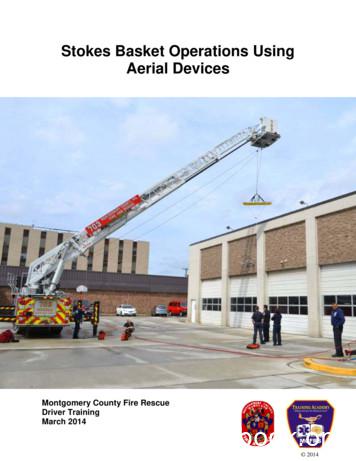
Stokes Basket Aerial Operations Best Practices Work within aerial ladder device manufacturer specifications and use good judgment. Deploy your system in a way that minimizes the potential for overstressing and/or shock loading equipment. Movement of an aerial device for the purpose of raising, lowering, or rotating a stokes basket
Before Operating Aerial Lifts Do not modify aerial lift without written permission Check safety devices, operating controls before each use Check area in which aerial lift will be used for: ¾ Level surface (Do not exceed manufacturer slope recommendations) ¾ Holes, drop-offs, bumps, debris, etc. ¾ Overhead obstructions and overhead power linesFile Size: 465KB
Astrophysics Research Institute The Astrophysics Research Institute (ARI) is one of the world’s leading authorities in astronomy and astrophysics. Its work encompasses a comprehensive programme of observational and theoretical research, telescope operation, instrument development, academic learning and outreach activities. The ARI has been honoured with various awards and prizes including: n .


