Latitude And Longitude - Ms. Melissa Muir
LatitudeandLongitudeActivities
Name:What is Latitude andLongitude?Latitude and longitude are words that geographers use to findthe location of a specific place on Earth. A geographer issomeone who studies the physical features of the Earth and theeffect that human activities have on places around the world.These lines are imaginary because you can’t see them. Lines oflatitude circle the Earth from east to west. Lines of longitudecircle the Earth from north to south.Identify which globe shows latitude and which shows longitude. Writethe term on the first lines below the globe and explain why you choseyour answers.Lines ofLines ofcircle the Earth fromcircle the Earth fromtoto The Teacher’s Prep
Name:Directions and DegreesequatorLines are itudeLongitude and latitude are measured in degrees.The equator divides the Earth in half. When finding latitude, alldegrees north of the equator can be written N (number) For example, N 40 All degrees south of the equator can be written S (number) For example, S 17 When finding longitude, the Earth is divided in half at the PrimeMeridian. All degrees east of the Prime Meridian will be writtenE (number) For example, E 7 All degrees west of the Prime Meridian will be written W (number) For example, W 27 The Teacher’s Prep
Name:Facts aboutLatitude and LongitudeLines of latitude andlongitude intersect at rightangles at the equator.equatorPrimeMeridianLines of latitude are alsocalled parallels because thelines run parallel to theequator. Each line oflatitude is about 69 milesapart. Lines of longitude arecalled meridians.Latitude and longitude aremeasured in degrees.longitudelatitudeEach line (degree) of latitude and longitude is divided evenly intosmaller sections called minutes and seconds. There are 60 minutesbetween each degree. Between each minute there are 60 seconds.Latitude and Longitude is written:N 40 41’ 26”W 74 2’ 54” is the degree‘ is the minutes“ is the seconds The Teacher’s Prep
Name:Key Terms and DefinitionsDirections: As you read, fill in the definitions for the words below.Use the blank boxes to define any words from the reading thatare new to you.geographerlatitudelongitudeequatorPrime Meridiandegreeparallelintersect The Teacher’s Prep
Name:Tools of a GeographerDirections: Use your knowledge of latitude and longitude to answerthe questions below.1. Describe the role of a geographer.2. Compare and contrast the lines of latitude and longitude. Howare they the same? How are they different?3. Fill in the blank: The divides the globe intonorth and south parts. The dividesthe globe into east and west parts.4. Rewrite this sentence to reflect the correct way to write latitude:30 degrees north, 50 minutes, 17 seconds5. Why are lines of latitude and longitude useful to a geographer? The Teacher’s Prep
Name:Think like a Geographer!Directions: Use the terms in the word bank to label the parts of theglobe and other symbols that relate to latitude and longitude.Prime MeridianminuteslongitudelatitudedegreesA line ofequatorsecondsA line ofN 40 41’ 26.88”
Name:Be a Geographer!Directions: You have just discovered a new island in the PacificOcean! Follow the arrows to mark the coordinates in order on thelatitude and longitude grid below to map the island. Draw a linebetween each of the coordinates to form a shape.N 29 W 137 N 30 W 136 N 31 W 134 N 29 W 132 N 27 W 133 N 26 W 136 My island is named:N 31 N 30 N 29 N 28 N 27 N 26 W 137 W 136 W 135 W 134 W 133 W 132
Name:How to use Google EarthStep 1Open the Google Earthprogram.Step 2At the top of the screen, look for the “View” menuoption. Click “View” then click “Grid”. A little checkmark will pop up next to the word “Grid”. You willbe able to see lines of latitude and longitude appearon the Earth.Step 3Look for the “Search” bar in the upper left portion ofthe screen.If the coordinates in your activity are written:N 29 58’ 37”E 31 8’ 11”Then type:N 29 58 37, E 31 8 11Click the “Search” button! The Teacher’s Prep
Name:Exploring EarthDirections: Use your skills as a geographer to find these coordinateson Google Earth. In the space provided, write down what you see asyou travel to each location.CoordinatesWhat I SawN 29 58’ 37”E 31 8’ 11”N 38 53’ 52”W 77 2’ 11”N 48 51’ 28”E 2 17’ 40”N 28 25’ 7”W 81 34’ 52”N 40 41’ 21”W 74 2’ 40”N 51 30’ 2”W 0 7’ 28”S 33 51’ 24”E 151 12’ 54”N 41 53’ 24”E 12 29’ 32”N 50⁰ 08' 38"W 96⁰ 52' 58" The Teacher’s Prep
Name:Write Like a GeographerDirections: Imagine that you are a geographer. Write a letter to afriend. Describe how you use the tools of a geographer (latitude andlongitude) to find places around the world. Include at least 2interesting facts about latitude and longitude in your letter.Dear ,Sincerely, The Teacher’s Prep
Lines of latitude are also called parallels because the lines run parallel to the equator. Each line of latitude is about 69 miles apart. Lines of longitude are called meridians. Latitude and longitude are measured in degrees. equator Latitude and Longitude is written: is the degree ' is the minutes " is the seconds longitude latitude Prime .
Latitude 3150 Latitude 3160 Latitude 3180 Latitude 3189 Latitude 3330 Latitude 3340 Latitude 3350 Latitude 3380 Latitude 3450 Latitude 3460 Latitude 3470 Latitude 3480 Latitude 3490 Latitude 3550 Latitude 3560 . EMC Storage HW - VNX
Latitude & Longitude Facts Various questions on the meaning of latitude and longitude and important lines of latitude and longitude. Understand the concept of latitude and longitude applied together. Apply the use of latitude and longitude together to locate and compare positions between items on maps. Enter the Latitude & Longitude I
3. map with longitude and latitude lines 4. Slips of paper with longitude and latitude locations that can be located on drop cloth. 5. checklist (Appendix C ) 6. Longitude/Latitude Assessment (Appendix D ) C. Key Vocabulary 1. Longitude: (meridians) imaginary lines going from the north to the south, but dividing the globe east and west.
3 Latitude and Longitude Answer the following questions: 1. Research the lines of latitude and longitude 2. Explain how to use them to locate places on Earth. 3. explain degrees and minutes 4. Explain the main lines of latitude and longitude. 5. What is the latitude and longitude for Rainham? London? Edinburgh? Cardiff? Manchester? Dr. Nagler's .
- Introduce latitude and longitude and its usage. - Practice locating different areas in the maps using latitude and longitude. Day 5 - Teacher will review the importance of maps, globes, latitude, and longitude. - Have students reflect on what they have learned during the week through a KWL Chart.
2. Use the Data Chart and World Map provided below to plot the following latitude and longitude coordinates. Be sure to label each point with the correct letter. DATA CHART ! WORLD MAP! Leigh-Manuell - "4 Lab Activity: Latitude and Longitude Location Latitude Longitude A 40º N 160º W B 40º S 40º E C 20º S 80º W D 80º N 120º W E 0º 0º
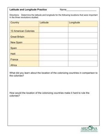
Latitude and Longitude Practice Answer Key Directions: Determine the latitude and longitude for the following locations that were important in the three revolutions studied. Country Latitude Longitude 13 American Colonies 40o North 80o West Great Britain 50o North 0o New Spain 24o North 1
dimensional structure of a protein, RNA species, or DNA regulatory element (e.g. a promoter) can provide clues to the way in which they function but proof that the correct mechanism has been elucid-ated requires the analysis of mutants that have amino acid or nucleotide changes at key residues (see Box 8.2). Classically, mutants are generated by treating the test organism with chemical or .


